To understand how a GPS tracker works, you must first understand what the Global Positioning System is.
A system that cost around $12 billion USD to build and launch, it’s absolutely incredible how the technology is now free for anyone to use.
GPS technology is a mainstay in many of our lives today, but initially, it wasn’t available to the public.
While it was initially created to be used on anything from a uniformed soldier to an armada of ships anywhere on the planet.
You can now use it to navigate a new neighbourhood, order food to your home, or find stolen vehicles.
But how is it so accurate?
GPS technology began to be developed back in the early 60s when the U.S. Navy needed a way to better track military assets.
By taking advantage of the “Doppler Effect”, scientists conducted experiments to track submarines carrying nuclear missiles.
Through the use of satellites orbiting the poles, submarines observed satellite movement using the “Doppler Effect” and were able to pinpoint the submarine’s location within minutes.
The next decade yielded advancements in the field, allowing the first Navigation System with Timing and Ranging (NAVSTAR) satellite that was successfully launched in 1978.
Fifteen years later, the satellite system became fully operational.
But how does the Global Positioning System work?
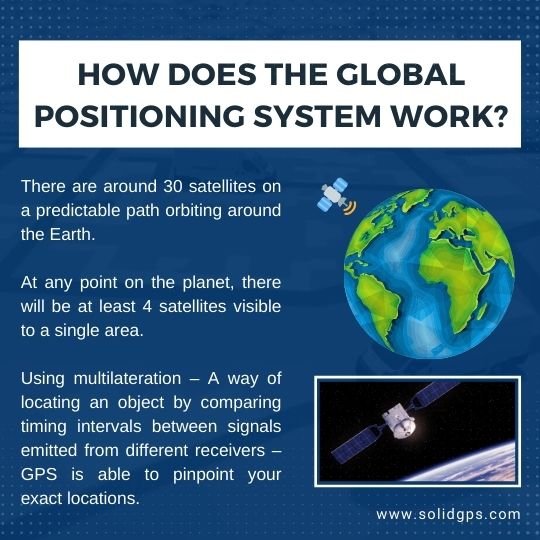
For the first few decades, once the Global Positioning System was developed, the public had access to severely limited access.
So, how did GPS fall into the hands of the public?

That very same year brought about a change in policy.
U.S. President Ronald Reagan announced that the Global Positioning System would be made available for civilian use, all for free. The United States maintains the Global Positioning System by spending approximately $2 million dollars every day.
Free use of this technology didn’t come without a catch.
Initially, the signals were scrambled to make them less accurate for everyday civilian use.
This was an inhibiting factor for organisations and individuals looking to use GPS for what it was designed for; accurate locating.

Unfettered use of this technology has been groundbreaking, but there is still one caveat: The Global Positioning System cannot be used above a certain height—approximately 10,000 feet.
This is to prevent missiles from using GPS as a targeting system.
So, how does a GPS tracker operate?
Let’s find out by using Solid GPS as an example.
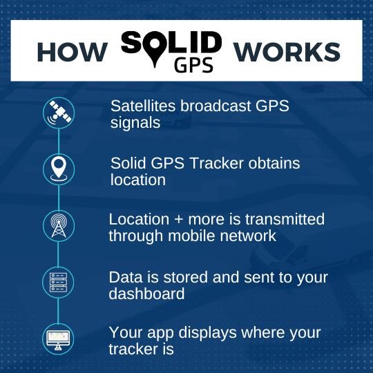
What occurs is your tracker picks up on multiple satellites orbiting the Earth, takes in their signal and calculates its own location.
In Solid GPS’ case, location data and other information are sent through the Telstra & Vodafone network through 4G.
Travelling at the speed of light that tracking information hits our servers, is unencrypted and ends up displayed on your dashboard where you can see your GPS tracker’s last location and other useful tidbits like speed, direction, signal strength, etc.
GPS tracking is a complex technology that is difficult to break down.
This means that there are many misconceptions surrounding it. Such as the following:
Since 1983, the use of GPS tracking technology has been free for everyone.
You may wonder why you need a SIM card for GPS tracking and why you can’t use a tracker without a subscription.
The answer is simple: GPS satellites are designed to only send out GPS signals, they don’t transmit incoming data.
For you to gain access to the data your GPS tracker stores, your tracker relies on SIM cards, cell towers and mobile networks to transmit that data to a server.
In our case, your data is sent to the Solid GPS servers and then to your dashboard where you can view your tracker.
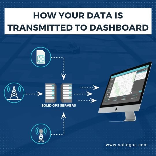
And so you have to cover the cost of the SIM card, data, server costs, app costs (if there is one) and customer support if you run into any trouble.
The GPS system most commonly used worldwide is operated and maintained by the United States.
It wouldn’t be outlandish to wonder how reliable that system really is.
While GPS has proven to be reliable thus far, many countries have chosen to safeguard themselves by running their own systems.
If America chose to shut off or limit its GPS system for any reason, there would be alternatives available.
A few countries that own and operate through their own systems include the following:
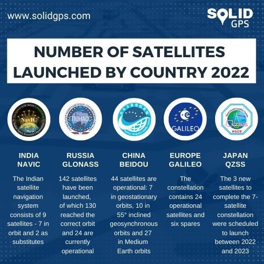
Several of these countries also have their own satellites launched, ensuring strong signals over their regions.
One of the biggest advantages we have to offer you is the fact that Solid GPS uses Multi-GNSS – instead of relying solely on America’s GPS system, we have access to multiple satellites from other satellite constellations including Galileo, GLONASS, and Bei-Dou.
Your tracker’s sim card utilises the mobile networks of over 500 mobile carriers, allowing you to access all with your Solid GPS tracker.
In Australia, this means you’ll have access to both Telstra and Vodafone.
The careful consideration we’ve given to the satellite systems of our choice ensures that we aren’t putting all our eggs in one basket.
Being invulnerable to a single point of failure makes our product reliable and able to help you track your assets as accurately as possible!
There are also a bunch more misconceptions about GPS trackers you can learn.
Here’s a picture of our tracking process again if you skipped over it.

If you have any more questions on how GPS trackers work, shoot us an email at support@solidgps.com or go to our support page.
And sign up below to get your free vehicle security blueprint that will bolster your car’s, motorcycle’s or caravan’s security fast and free.

Solid GPS is based in Melbourne, Victoria. All design, development and assembly is done in-house.
© Copyright 2025 Solid GPS
Privacy Policy | Terms & Conditions
Get $50 Off The MEGA Solid GPS Tracker.
(And free shipping).
Only Available Until The 27th of November.
Just enter your email below and we’ll send it through.
You’ll also get our emails every once and a while.
We won’t share your info with third parties and you can easily unsubscribe at the bottom of every email.